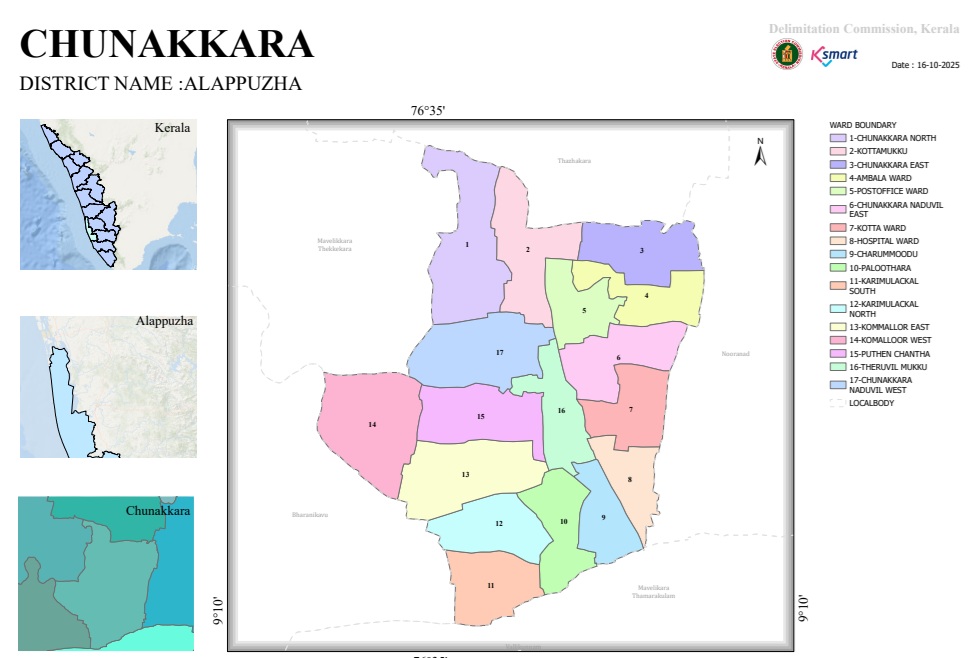
Map 2026

Ward Map 2026

1. General Information

Local Self-Government Institution: Chunakkara Grama Panchayat
District: Alappuzha
Total Number of Wards: 17
Date of Map Preparation: 16-10-2025
Approximate Latitude and Longitude: 9°10' N, 76°35' E

2. Geographical Location of the Panchayat

Chunakkara Grama Panchayat is located in the eastern region of Alappuzha district. The Panchayat shares its boundaries with the following areas:

  • North: Thazhakara
  • East: Nooranad
  • South: Thamarakulam and Vallikunnam
  • West: Bharanikkavu and Thekkekara

3. List of Wards

Chunakkara Grama Panchayat is divided into 17 wards.

Ward No.Ward Name
1Chunakkara North
2Kottamukku
3Chunakkara East
4Ambala Ward
5Post Office Ward
6Chunakkara Naduvil East
7Kotta Ward
8Hospital Ward
9Charummood
10Paloothara
11Karimulakkal South
12Karimulakkal North
13Komalloor East
14Komalloor West
15Puthenchantha
16Theruvilmukku
17Chunakkara Naduvil West

4. Key Features of the Ward Arrangement

  • The northern region mainly comprises Wards 1, 2, and 3.
  • The central region includes Wards 5, 6, 16, and 17, which function as the Panchayat’s administrative and transportation hubs.
  • The southern region consists of Wards 9, 10, 11, and 12.
  • The western region includes Wards 14, 15, and 17.
  • The eastern region comprises Wards 4, 7, 8, and 9.
  • Ward 17 (Chunakkara Naduvil West) is located in the central part of the Panchayat and therefore shares boundaries with several other wards.

5. Administrative Assessment

  • The division into 17 wards helps ensure effective and equitable public representation.
  • The arrangement of the centrally located wards facilitates better access to public services and administrative functions.
  • Names such as Charummood, Hospital Ward, and Post Office Ward reflect important service and activity centers within the Panchayat.
  • The ward boundaries appear to have been delineated based on both natural features and administrative considerations, as evident from the ward map.

6. Conclusion

The 2026 Ward Delimitation Map of Chunakkara Grama Panchayat organizes the Panchayat into 17 wards. This division has been designed by taking into account local characteristics, population distribution, and administrative convenience, thereby supporting the effective implementation of local self-government functions. The ward structure ensures balanced representation of the Panchayat’s central, northern, southern, eastern, and western regions, contributing to efficient governance and service delivery.


Map 2026
  • final notification 2026